
You know where an old couch belongs? In a creek of course. What can be more witty than its homely form – its ludicrous, puffy bulk – half immersed in water. Indeed one can almost imagine the couch getting there on its own, making its way silently through the suburbs to this reservoir of comfort. The creek holds the couch quietly, calling on it to reflect, which it does for a time until wilds nights put an end to meditation and drag it out to sea.
All posts by Brogan Bunt
Fairy Creek Walk Reflections, by Eva Hampel

WOTI ran a walk for participants in the EcoArts Australis 2nd National Conference (14-16 February, 2016). A group of about twelve of us started at the Lagoon restaurant and wandered up Fairy Creek, discovering thriving weeds, multiple creek branches and miraculous drainway passages between railway lines and roads. One of our guest walkers, Eva Hampel, wrote the following:
A small coastal creek: degraded, weed-banked, a little creepy, in places almost impenetrable. Thickets of lantana, littered with flood-deposited plastic refuse, time and again bringing us to a halt. But still in some places almost intact casuarina swamp forest with native grasses, beautiful soft couch as an understorey, and the sound of the breeze soughing in the needles overhead. Makes you think: how beautiful must this place have been in pre-European times? What a luxurious, well-supplied living room it must have been when only Aboriginal people lived here – rich with fish, shellfish, tubers, native spinach and other native plants, with fresh water plentiful nearby, and soft grass on which to sit and feast.
For how long did this idyllic environment survive European settlement and the disturbance of agriculture? For quite a while it must have remained beautiful: a place of refuge for wildlife, for Aboriginal owners a setting for continued occupation (where allowed – that history is not pretty), for European settlers a place for picnics and swimming; shaded, wind-protected, and with deep still pools, waterbirds, and quiet reflections. But gradually the weeds would have moved in – and with industrialisation of the area, the neglect of peripheral spaces: behind the factory, beside the road/rail/driveway, bordering the parking area; weeds have been allowed to grow unchecked, and the degradation is almost complete.
And yet what a treasure these passages could be! These are ribbons of largely public space, reaching from deep in the coastal suburbs to the surf beaches: see them as ribbon parklands, perhaps a cycleway, at least a creekside track. Large-scale weed clearance would be needed, but once the worst was cleared out, local groups would likely be roused to their defence, once they became a public asset, a path to the ocean. Even now hardy dog-owners manage to navigate them in parts, graffiti artists use drainage tunnels as canvases, and hideaways have been built here and there, despite a vague sense of threat and possible sinister things. These are spaces that people value – if some are brave enough to inhabit them now, how many more would use them once the sense of potential threat had been removed?
Should this be a call to arms? Could the local Council, perhaps cash-strapped, certainly with priorities firmly set on ‘front-of-house’ spaces – like roadways, established parks, formal sports playing grounds – be encouraged to view these spaces as assets, local spaces for local people, along with the beaches and escarpment which are iconic local attractions? Is it just the idealist in me, blended with the compulsive planner and landscape architect, that cries at the lack of vision and waste of this approach to such spaces?
Can art change the world? Well, certainly it can build a groundswell for action. I think this is a call to arms….
Eva Hampel
B11 – Hut Gulch
Difficulty: steep and full of old bricks and iron.
Summary: small creek bed – scarcely flowing, even after rain.
Directions: Continue south from B10. Near a tiny hut.
Point of disappearance: no reason to ascend.

B10 – Seeping Cliff
Difficulty: steep and loose.
Summary: seeping cliff rising directly above the beach to a Norfolk pine tree and a small lookout. No doubt rain dependent.
Directions: Continue walking south from B9 to a small beach and the cliff on the right.
Point of disappearance: not tempting to ascend.

B9 – Small Waterfall
Difficulty: overhanging
Summary: a small waterfall beneath Clifton. Most likely only runs after rain.
Directions: Park at Clifton car park – just north of the Clifton School of Art. Walk across the road to Maronga Park to an ill-defined track at the northern edge of the park. Descend steeply down to the coastal rock shelf. The track is literally only metres south of B8 and much easier than the B8 ascent. B9 is visible a short way down the coast on the right.
Point of disappearance: approached base of waterfall, but too steep to proceed any further.


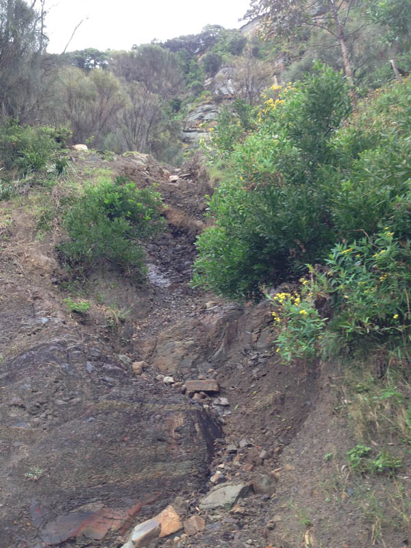
B8 – Creek and Scrub Exit *
Difficulty: creek section tricky in rain. Upper section involves full body scrub crawling.
Summary: steep, boulder strewn creek a few hundred metres north of Clifton.
Directions: continue on from finish of B7 around rocks and a slippery, seaweed strewn cove to another large rock shelf with a deep central sea inlet. The walk around the cove is likely to be tide dependent so visit close to low tide. A small creek runs down through boulders to the rock shelf and sea. Follow the creek up through a series of small cascades to just beneath the steepest section. In rain this involves some delicate climbing on slippery rocks. Avoid the very steepest section by mantling up on to a steep grassy slope at a large palm tree on the right . Continue up into the low forest and past dumped rubbish to a small campsite with a black plastic tarpaulin tent, milk crates of supplies and large bundles of empty water bottles hanging from the trees. Is this a fisherman’s camp? A criminal’s lair? Or a homeless person’s hideaway? No way of knowing and wary of finding out. Veer slightly right and upwards into the apparently impassable Lantana. Hear the sound of Lawrence Hargrave Drive traffic some short distance above. Crawl through the dense scrub until an overgrown track is reached. Follow the track north a short way and then struggle through a final bit of scrub to the southern end of the Sea Cliff Bridge walkway. Jump across the high fence and walk back to Coalcliff. The ascent from sea takes 30 minutes or so.
Point of disappearance: all thought of following the creek is lost upon stumbling across the hidden camp.


B7 – Seeping Cliffs Beneath Sea Cliff Bridge **
Difficulty: some narrow paths above rocks and sea. Bits and pieces of hazardous rusted metal.
Summary: Many saunter along the top of the Sea Cliff Bridge, gazing down at the surf crashing on the rock shelves far below and out to the horizon with its distant ships. Walking beneath the bridge is a different experience. Towering grey pylons, dumped rubbish, graffiti, loose, seeping coal cliffs and a single, rain dependent, small stream.
Directions: As for B6, but instead of crossing the road to the escarpment side and ascending the concrete spillway at the pine tree cove, turn left, jump over the fence and head down a broad, easy track to the coastal rock shelf below, then follow the bridge pylons around to beneath the southern end of the Sea Cliff bridge. At one point compelled to stray up the slope on the escarpment side. Follow a grassy stream bed back to the pylons. Continue south past evidence of old coal mining activity (framing timber sticking out of the shale walls, old mesh fences, twisted bits of rusted metal) to a large section of low, blocky cliff. Walk past old steel ladders leading up to mine entrances and then back down to the coastal rock shelf. 25 minutes from the cove.
Point of disappearance: nothing worth ascending – and all too difficult in any case.


B7a: Seeping algae cliff wall


B7b: Rainwater stream down grassy slope


B7c: Seeping coal cliff

B7d: Seeping coal cliff

B7e: Seeping coal cliff

B7f: Seeping coal cliff

B7g: Seeping coal cliff

B7h: Seeping coal cliff

B7i: Seeping coal cliff

B7j: Seeping coal cliff

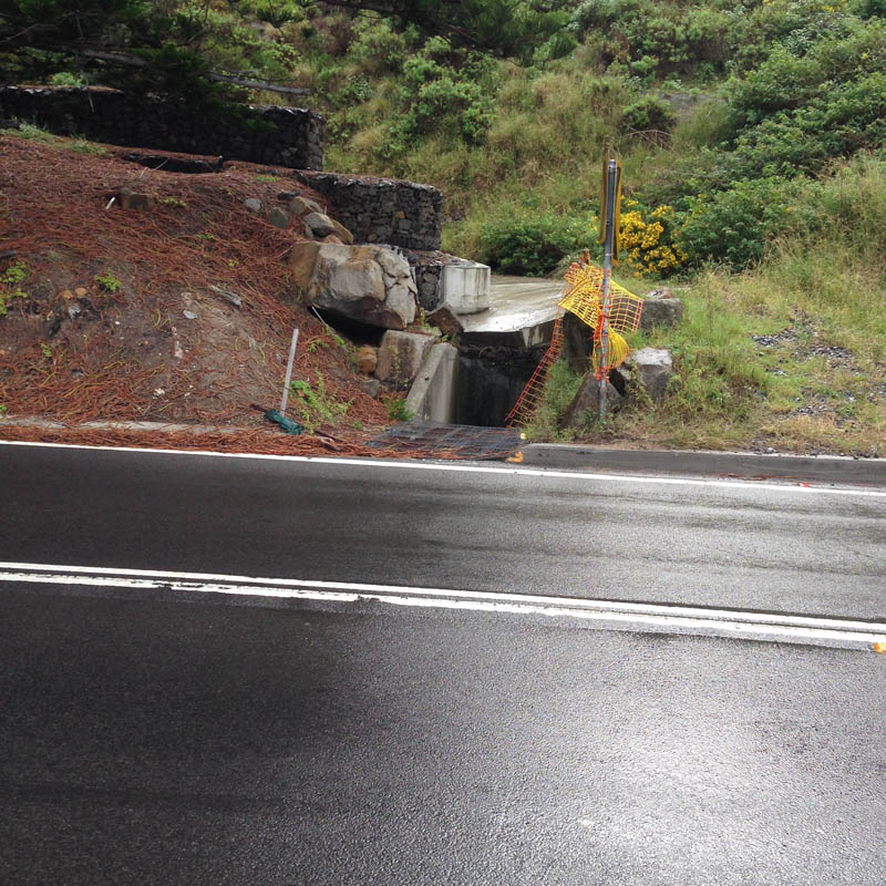
B6 – Landslide Zone at Northern End of Sea Cliff Bridge
Difficulty: easy down low, though objective landslide risk. Likely to be hard further up.
Summary: scarcely a creek at all. A wide concrete sluice, ending at a small drain beneath northern start of Sea Cliff Bridge. Seems to be as much about blocking falling rocks from the road as directing water from the steep slope above.
Directions: park at Leeder Park, Coalcliff. Follow trail from park down across Stoney Creek and then walk up and turn left at Paterson Road. Proceed up to Lawrence Hargrave Drive and turn left on to the start of the Sea Cliff Bridge. Walk along to a small cove with pine trees. The B6 entrance is on the opposite (western) side of the road. Cross the road carefully and walk up a gently inclined concrete floodway/rockfall drop-zone to a steep, muddy landslide creek on the right. 30 minute round trip.
Point of disappearance: the numbered boulders are sufficient to suggest that it is not such a good idea to walk up here. Decide not to ascend the landslide.


B5 – Stoney Creek *
Difficulty: surprisingly difficult, given that this pretty creek runs right through Coalcliff. You’d expect a small track on one or other side of its banks, but no track readily discernible. On the western side of Lawrence Hargrave Drive, the difficulty obtains another dimension. The creek runs through privately owned and fenced coal mining land.
Summary: a bouldery creek running down to Coalcliff beach. Included within B5 are whole series of small suburban drains that direct local runoff down towards the creek proper. These are most obvious along Lawrence Hargrave Drive from Coalcliff Station to the bridge across Stoney Creek.
Directions: either continue on from B4 and descend down Lawrence Hargrave Drive to Stoney Creek bridge and left to Leeder Park and Coalcliff Beach or alternatively park at Leeder Park and walk up to Coalcliff Station and back down to the park and the beach.
Point of disappearance: the small drains seems awkward to follow. Stoney Creek itself deserves more determined exploration, but it was raining heavily, so thought better of it.
B5a…: any number of small drains and watercourses running beneath Lawrence Hargrave Drive on the steep descent from Coalcliff Station to Stoney Creek.


B5 (proper): Stoney Creek


B4 – Drains North of Coalcliff Station
Difficulty: awkward, only occasionally navigable. Also worth taking care walking alongside Lawrence Hargrave Drive in this section. The road is very narrow with only a minimal verge.
Summary: a series of minor waterways appearing as road and railway drains (30-40 minutes one way)
Directions: park at Stanwell Park Beach Reserve, walk down to the beach and then to the mouth of Stanwell Creek. Cross the creek at some boulders and walk beside low cliffs for a short way until a small tributary runs into Stanwell Creek from between some impressive beach side houses (about 40m). Turn left and ascend the steep Kallaroo Avenue. Turn right at Lower Coast Road and then left at a small dirt track that leads up to Lawrence Hargrave Drive. Follow the latter south towards Coalcliff. The following collection of minor waterways occur at regular intervals along this narrow section of road.
Point of disappearance: immediate in most instances. These are generally narrow drains running beneath the road and railway lines. It would be worth walking the rocky coast for below to see if any cascade off the coastal cliffs as waterfalls. Possibly worth also walking the escarpment above in search of small creeklets and cascades.
B4a: an interesting, steep brick-lined drain on the western side of the road. Very slippery in wet weather. Leads up to a short section of natural creek, then to railway drains.


B4b: road drain, which becomes a short, noisy creek on the eastern side as it runs beside the southern end of a small section of open, grassed parkland.


B4c, B4d and B4e: another few railway and road drains, including one running beneath Coalcliff Station.

