Summary: a small waterfall beneath Clifton. Most likely only runs after rain.
Directions: Park at Clifton car park – just north of the Clifton School of Art. Walk across the road to Maronga Park to an ill-defined track at the northern edge of the park. Descend steeply down to the coastal rock shelf. The track is literally only metres south of B8 and much easier than the B8 ascent. B9 is visible a short way down the coast on the right.
Point of disappearance: approached base of waterfall, but too steep to proceed any further.
Difficulty: creek section tricky in rain. Upper section involves full body scrub crawling.
Summary: steep, boulder strewn creek a few hundred metres north of Clifton.
Directions: continue on from finish of B7 around rocks and a slippery, seaweed strewn cove to another large rock shelf with a deep central sea inlet. The walk around the cove is likely to be tide dependent so visit close to low tide. A small creek runs down through boulders to the rock shelf and sea. Follow the creek up through a series of small cascades to just beneath the steepest section. In rain this involves some delicate climbing on slippery rocks. Avoid the very steepest section by mantling up on to a steep grassy slope at a large palm tree on the right . Continue up into the low forest and past dumped rubbish to a small campsite with a black plastic tarpaulin tent, milk crates of supplies and large bundles of empty water bottles hanging from the trees. Is this a fisherman’s camp? A criminal’s lair? Or a homeless person’s hideaway? No way of knowing and wary of finding out. Veer slightly right and upwards into the apparently impassable Lantana. Hear the sound of Lawrence Hargrave Drive traffic some short distance above. Crawl through the dense scrub until an overgrown track is reached. Follow the track north a short way and then struggle through a final bit of scrub to the southern end of the Sea Cliff Bridge walkway. Jump across the high fence and walk back to Coalcliff. The ascent from sea takes 30 minutes or so.
Point of disappearance: all thought of following the creek is lost upon stumbling across the hidden camp.
B3 – B8Bottom of the creekCascadesCamp suppliesBack on the Sea Cliff Bridge trackView back down the weedy ascent
Difficulty: some narrow paths above rocks and sea. Bits and pieces of hazardous rusted metal.
Summary: Many saunter along the top of the Sea Cliff Bridge, gazing down at the surf crashing on the rock shelves far below and out to the horizon with its distant ships. Walking beneath the bridge is a different experience. Towering grey pylons, dumped rubbish, graffiti, loose, seeping coal cliffs and a single, rain dependent, small stream.
Directions: As for B6, but instead of crossing the road to the escarpment side and ascending the concrete spillway at the pine tree cove, turn left, jump over the fence and head down a broad, easy track to the coastal rock shelf below, then follow the bridge pylons around to beneath the southern end of the Sea Cliff bridge. At one point compelled to stray up the slope on the escarpment side. Follow a grassy stream bed back to the pylons. Continue south past evidence of old coal mining activity (framing timber sticking out of the shale walls, old mesh fences, twisted bits of rusted metal) to a large section of low, blocky cliff. Walk past old steel ladders leading up to mine entrances and then back down to the coastal rock shelf. 25 minutes from the cove.
Point of disappearance: nothing worth ascending – and all too difficult in any case.
Difficulty: easy down low, though objective landslide risk. Likely to be hard further up.
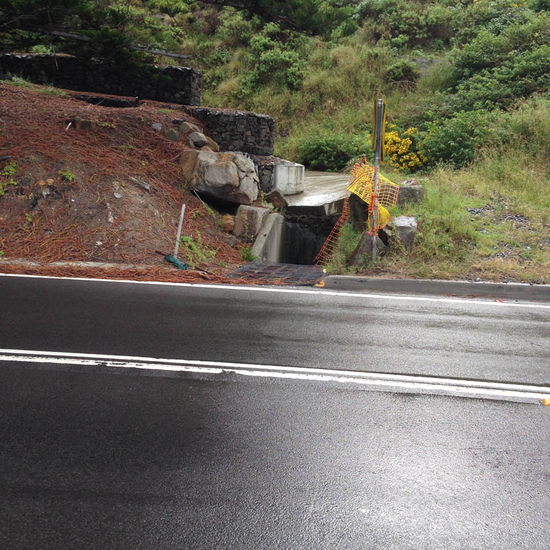
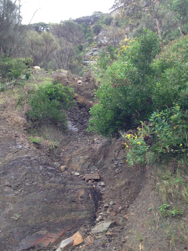
Summary: scarcely a creek at all. A wide concrete sluice, ending at a small drain beneath northern start of Sea Cliff Bridge. Seems to be as much about blocking falling rocks from the road as directing water from the steep slope above.
Directions: park at Leeder Park, Coalcliff. Follow trail from park down across Stoney Creek and then walk up and turn left at Paterson Road. Proceed up to Lawrence Hargrave Drive and turn left on to the start of the Sea Cliff Bridge. Walk along to a small cove with pine trees. The B6 entrance is on the opposite (western) side of the road. Cross the road carefully and walk up a gently inclined concrete floodway/rockfall drop-zone to a steep, muddy landslide creek on the right. 30 minute round trip.
Point of disappearance: the numbered boulders are sufficient to suggest that it is not such a good idea to walk up here. Decide not to ascend the landslide.
B3 – B8B6 startSpillway/boulder zoneNumbered rockfallMudslide creekA view of the bridge
Difficulty: surprisingly difficult, given that this pretty creek runs right through Coalcliff. You’d expect a small track on one or other side of its banks, but no track readily discernible. On the western side of Lawrence Hargrave Drive, the difficulty obtains another dimension. The creek runs through privately owned and fenced coal mining land.
Summary: a bouldery creek running down to Coalcliff beach. Included within B5 are whole series of small suburban drains that direct local runoff down towards the creek proper. These are most obvious along Lawrence Hargrave Drive from Coalcliff Station to the bridge across Stoney Creek.
Directions: either continue on from B4 and descend down Lawrence Hargrave Drive to Stoney Creek bridge and left to Leeder Park and Coalcliff Beach or alternatively park at Leeder Park and walk up to Coalcliff Station and back down to the park and the beach.
Point of disappearance: the small drains seems awkward to follow. Stoney Creek itself deserves more determined exploration, but it was raining heavily, so thought better of it.
B3 – B8
B5a…: any number of small drains and watercourses running beneath Lawrence Hargrave Drive on the steep descent from Coalcliff Station to Stoney Creek.
Runoff pipeRoadside cascadeSteep drop-off on eastern sideSmall watercourse in rain
B5 (proper): Stoney Creek
Stoney Creek mouthStoney Creek from Leeder Park bridgebridge at Lawrence Hargrave DriveUnder view of bridge
Difficulty: awkward, only occasionally navigable. Also worth taking care walking alongside Lawrence Hargrave Drive in this section. The road is very narrow with only a minimal verge.
Summary: a series of minor waterways appearing as road and railway drains (30-40 minutes one way)
Directions: park at Stanwell Park Beach Reserve, walk down to the beach and then to the mouth of Stanwell Creek. Cross the creek at some boulders and walk beside low cliffs for a short way until a small tributary runs into Stanwell Creek from between some impressive beach side houses (about 40m). Turn left and ascend the steep Kallaroo Avenue. Turn right at Lower Coast Road and then left at a small dirt track that leads up to Lawrence Hargrave Drive. Follow the latter south towards Coalcliff. The following collection of minor waterways occur at regular intervals along this narrow section of road.
Point of disappearance: immediate in most instances. These are generally narrow drains running beneath the road and railway lines. It would be worth walking the rocky coast for below to see if any cascade off the coastal cliffs as waterfalls. Possibly worth also walking the escarpment above in search of small creeklets and cascades.
B3 – B8
B4a: an interesting, steep brick-lined drain on the western side of the road. Very slippery in wet weather. Leads up to a short section of natural creek, then to railway drains.
Aqueduct style brick shuteCreek line to railway drainLooking back down the awkward clamber required to escape the drainRailway drain, not navigable
B4b: road drain, which becomes a short, noisy creek on the eastern side as it runs beside the southern end of a small section of open, grassed parkland.
Deep drainView out to sea from the parkland
B4c, B4d and B4e: another few railway and road drains, including one running beneath Coalcliff Station.
Railway drainRoad drain close to Coalcliff Station
Summary: one of the best waterway walks in the northern Illawarra, varied and interesting. 25 minutes one way.
Directions: Park at Stanwell Park Beach Reserve. Walk down to beach and then to the southern end. Stanwell Creek meets the sea just before the cliffs. Follow inland closely beside the creek on the northern side. Note the impressive houses perched on the steep opposite slopes, the barnacles on the low cliffs and the ancient tree trunks in the creek. Follow up to Beach Rd and then turn left. Proceed along past the low bridge with its flood markers and continue up the hill (now Lower Coast Road). After 100m or so, just as the road begins to veer right into the suburbs, follow a small trail down to the left. It leads back down to the creek, specifically a section with a deep pool and a rope swing at the mouth of huge brick road tunnel (passing beneath Lawrence Hargrave Drive). Walk through the well graffitied tunnel. At the other end, Stanwell creek appears as a bouldery rainforest waterway heading up gradually into the escarpment.
Point of disappearance: too wet to boulder hop. The rainforest section must wait till another day.
Stanwell Park waterwaysStanwell Creek mouthLooking up from the beachLagoonGraffiti at entrance to road tunnel
Summary: a short walk up Hargrave Creek from the beach lagoon and through a short section of forest to Lawrence Hargrave Drive. 15 minutes or so.
Directions: park at Stanwell Park Beach Reserve. Walk down to the beach and then to the northern side of the Hargrave Creek lagoon. Follow a sandy track alongside the creek back inland. Cross back to the southern side at a small pedestrian bridge. Continue alongside the creek through the beach reserve. Just after some picnic shelters turn right back across to the northern side of the creek on another pedestrian bridge. The creek is forested here. Follow the bush trail up to Park Parade. Turn left and proceed for 80 metres or so along the road until a small track is discerned on the right heading up more steeply through the bush. A mesh fence prevents entry to the creek on the right. Continue up to Lawrence Hargrave Drive.
Point of disappearance: Lawrence Hargrave Drive runs directly across the old creek ravine, which has now been filled and replaced by drainage pipes. It would be possible to continue across Lawrence Hargrave Drive and re-find the creek, but it is essentially lost for me as it passes deeply beneath the road.
Stanwell Park waterwaysHargrave Creek (not quite reaching the sea)
Summary: a small waterfall at the northern end of Stanwell Park beach.
Directions: Park at Stanwell Park Beach Reserve. Walk down to beach and then up to the northern end. Scramble across a section of rocks. After 50m or so encounter a small, stepped waterfall on your left.
Point of disappearance: a rainy day, unable to climb.